


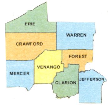
County guides for the eight counties of Northwest Pennsylvania: Clarion, Crawford, Erie, Forest, Jefferson, Mercer, Venango, and Warren.
In March 1800, several counties, including Crawford County, were carved from parts of Allegheny County; most of the others created at that time remained “attached” to Crawford County for several years before being formally organized. These included Erie, Mercer, Venango, and Warren counties.
In 1804, Jefferson County was formed from Lycoming County. Years later, in 1839, Clarion County was formed from Armstrong and Venango counties, and finally, in 1848, Forest County was carved from portions of Jefferson and Venango counties.
HISTORY
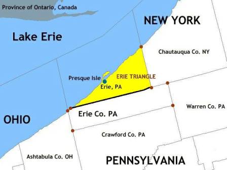
It’s said that no white man trod this area before 1700 – Europeans first arrived in the region when the French constructed Fort Presque Isle near present-day Erie in 1753; the abandoned it to the British in 1760. After the Revolutionary War, as states sought to define their boundaries, Pennsylvania looked to expand into this area, known as the Erie Triangle, hoping to gain access not only to Lake Erie but also the Great Lakes and St. Lawrence Seaway. Bordered by Lake Erie on the north, the 42nd Parallel on the south, and New York’s western boundary on the east, the Erie Triangle had been claimed by Connecticut, Massachusetts, and New York; all of them relinquished their claims to the federal government, which in turn sold it to Pennsylvania in 1792.
Initial settlement of the area – mostly wilderness – began in 1795. Soldiers of the Pennsylvania Line who’d served during the war were granted rights to land in Crawford and Mercer counties, parts of Forest, Venango, and Warren counties, and some of Erie County that lay south of the triangle. They were to find fertile soil, a temperate climate, and an abundance of fresh streams and creeks.
Not surprisingly, Erie – the largest city in the region (and fourth largest in the state today) – emerged as a maritime center after the Revolution. Later, it became a railroad hub as the country expanded westward because it was where three sets of different size track gauges met (this was before one national gauge became the standard),
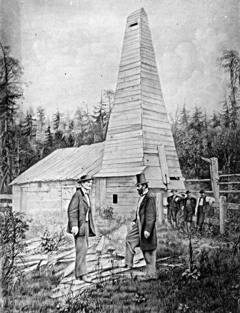
During the Industrial Revolution, Erie became known for iron and steel manufacturing, but the defining moment for this region took place in 1859, when the Drake Well was drilled in Titusville. The first well drilled solely for the purpose of finding oil, it’s considered the most important oil well ever drilled as it triggered an international search for petroleum, eventually changing the way we live. Overnight, the quiet farming region changed – towns quickly sprung up and people came from all over, seeking their fortune. As hundreds of wells sprang up, the sounds of steam engines and other machines filled the air.
Most of the people who reside in Erie today are of European descent but beginning in the early 1900s and continuing to remain steady, a large community of Russian immigrants has settled in Erie. Many of these immigrants have found work in the shipyards and related maritime occupations.
GSP welcomes your suggestions, knowledge and guidance to genealogical resources within any area of Pennsylvania in which you live and do your own research.
If you have information to share about local societies or repository resources, historical knowledge of the local area, or any other relevant genealogical information that could help people find their ancestors, please contact GSP so we can add this information to the County page. Thank you!
Thank you to Jane Benner for her contribution to this page!
Image credits:
Northwest Pennsylvania Region Map courtesy of www.digital-topo-maps.com
Center right: Erie Triangle within Erie County. Foundation map created via National Atlas online mapmaker, a public domain resource of the U.S. government. Wikimedia Commons
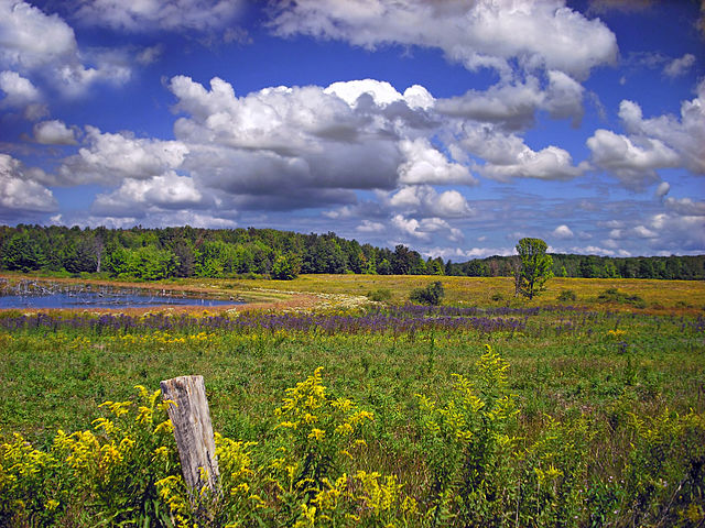
Center left: Erie National Wildlife Refuge. Wikimedia Commons, contributor Nicholas.
Bottom right: Drake Well, 1859. Reproduction, copyrighted 1890, of retouched photograph with Edwin L. Drake (right) in front of the Drake Well, Titusville, PA. Library of Congress, ID – LC-USZ62-11724.)