


When searching for records during these time periods, keep in mind the county formation dates below. The farms didn’t move – the boundaries around them did!
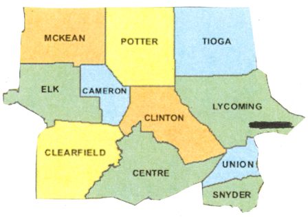
North Central
This region includes 11 counties: Centre, Cameron, Clearfield, Clinton, Elk, Lycoming, McKean, Potter, Snyder, Tioga, and Union.
Lycoming was formed in 1795 from Northumberland County, followed by Centre County in 1800 from Lycoming, Mifflin, Northumberland, and Huntingdon counties. In 1804, parts of Lycoming County were split off to form four other counties: Clearfield (which also included some of Huntingdon County), McKean, Potter, and Tioga. Then Union County was formed in 1813 from Northumberland. Over 25 years passed before another county was formed: Clinton came from Lycoming and Centre counties in 1839. Elk County was formed from Jefferson, McKean, and Clearfield counties in 1843, and Snyder was carved from Union County in1855. Finally, in 1860, Cameron County was formed from portions of Clinton, Elk, McKean, and Potter counties.
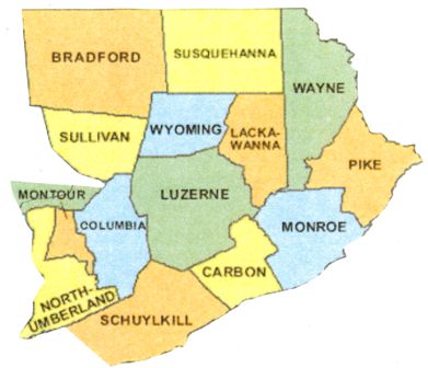
Northeast
Northeast Pennsylvania includes 14 counties: Bradford, Carbon, Columbia, Lackawanna, Luzerne, Monroe, Montour, Northumberland, Pike, Schuylkill, Sullivan, Susquehanna, Wayne, and Wyoming.
Northumberland was formed in 1772 from Bedford, Berks, Cumberland, Lancaster, and Northampton counties; in 1786, Luzerne County was formed from part of Northumberland, and in 1798, Wayne County was formed from part of Northampton County. In 1810, Bradford County was carved from Luzerne and Lycoming counties, and Susquehanna from Luzerne County. The following year Schuylkill County was created from parts of Berks and Northampton counties. Columbia County was formed from Northumberland in 1813, and Pike followed in 1814 from Wayne County. Over 20 years later, Monroe County was formed from Northampton and Pike counties. In 1842, Wyoming County was formed from Luzerne County, followed in 1843 by Carbon, formed from Monroe and Northampton counties. Sullivan County was carved from Lycoming County a few years later, in 1847; then Montour was formed from Columbia County in 1850. Finally, in 1878, Lackawanna (the last of Pennsylvania’s 67 counties) was formed from Luzerne County.
Northwest
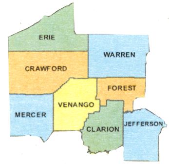
This region encompasses eight counties: Clarion, Crawford, Erie, Forest, Jefferson, Mercer, Venango, and Warren.
In March 1800, several counties, including Crawford County, were carved from parts of Allegheny County; most of the others created at that time remained “attached” to Crawford County for several years before being formally organized. These included Erie, Mercer, Venango, and Warren counties. In 1804, Jefferson County was formed from Lycoming County. Years later, in 1839, Clarion County was formed from Armstrong and Venango counties, and finally, in 1848, Forest County was carved from portions of Jefferson and Venango counties.
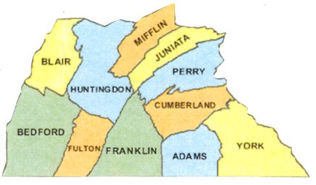
South Central
This region comprises 12 counties: Adams, Bedford, Blair, Cumberland, Dauphin, Franklin, Fulton, Huntingdon, Juniata, Mifflin, Perry, and York.
York was formed in 1749 from Lancaster County; in 1750, Cumberland County also was formed primarily from Lancaster County. Over 20 years later, in 1771, Bedford County was carved from Cumberland, as was Franklin County in 1784. Dauphin County was formed from part of Lancaster County in 1785, then Huntingdon County from Bedford County in 1787. In 1789, Mifflin County was formed from Cumberland and Northumberland counties, and in 1800, Adams County was carved from York County. The other four counties were formed over the next 50 years: Perry in 1820 from Cumberland; Juniata in 1831 from Mifflin; Blair in 1846 from Bedford and Huntingdon counties; and Fulton in 1850 from Bedford.
Southeast
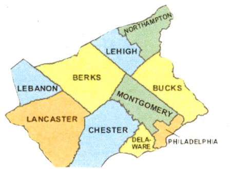
The region is comprised of 10 counties: Berks, Bucks, Chester, Delaware, Lancaster, Lebanon, Lehigh, Montgomery, Northampton, and Philadelphia.
The three original counties, created by William Penn in 1682, include Philadelphia, Bucks, and Chester. Some 50 years later the next county – Lancaster – was carved out of Chester County in 1728. Berks County was formed from Chester, Lancaster, and Philadelphia counties in 1752 and the same year Northampton County was created from Bucks County. In 1784 Montgomery County was carved from Philadelphia, and in 1789 Delaware County was formed from Chester. Lehigh County was created from part of Northampton County in 1812, followed by Lebanon County in 1813, which was created from Dauphin and Lancaster counties.
Southwest
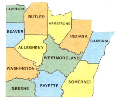
This region encompasses 12 counties: Allegheny, Armstrong, Beaver, Butler, Cambria, Fayette, Greene, Indiana, Lawrence, Somerset, Washington, and Westmoreland.
In 1773, Westmoreland County was established, the first in Pennsylvania west of the Allegheny Mountains. All or parts of several other southwestern counties were formed from it: Washington (1781), Fayette (1783), Allegheny (1788), Greene (1796). In 1795, Somerset County was formed, followed in 1800 by Armstrong, Beaver, and Butler counties; then Cambria and Indiana in 1803, and finally, Lawrence in 1849. This development reflects the population growth west of the Alleghenies between 1790 (75,000) and 1800 (139,000).
Regional maps courtesy of www.digital-topo-maps.com